I've mapped the beautiful Spanish island of #Formentera on #OpenStreetMap.
-
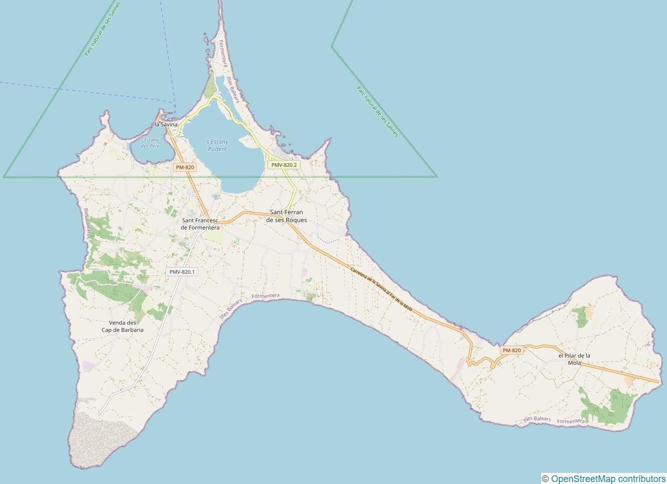
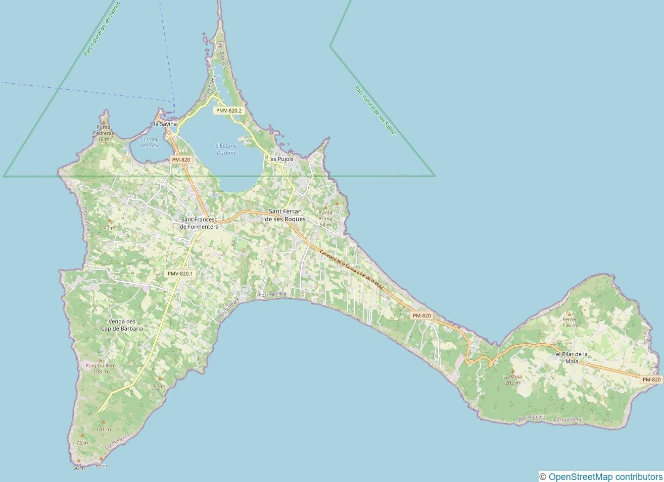
I've mapped the beautiful Spanish island of #Formentera on #OpenStreetMap. It was an exciting challenge to record street names, addresses, rural addresses, POIs, landcover and more. Formentera covers an area of approximately 83 km² (32 mi²).
Here's a #BeforeAndAfter impression:
@thefabi Woah! Congrats!
-
I've mapped the beautiful Spanish island of #Formentera on #OpenStreetMap. It was an exciting challenge to record street names, addresses, rural addresses, POIs, landcover and more. Formentera covers an area of approximately 83 km² (32 mi²).
Here's a #BeforeAndAfter impression:
@thefabi I still remember when my driving with Waze confirmed the existence of roads. Yes, I did use Waze that long ago. B.G. (Before Google acquired it)
-
I've mapped the beautiful Spanish island of #Formentera on #OpenStreetMap. It was an exciting challenge to record street names, addresses, rural addresses, POIs, landcover and more. Formentera covers an area of approximately 83 km² (32 mi²).
Here's a #BeforeAndAfter impression:
@thefabi nice work
.thank you very much for your contribution -
I've mapped the beautiful Spanish island of #Formentera on #OpenStreetMap. It was an exciting challenge to record street names, addresses, rural addresses, POIs, landcover and more. Formentera covers an area of approximately 83 km² (32 mi²).
Here's a #BeforeAndAfter impression:
@thefabi Wow!
-
I've mapped the beautiful Spanish island of #Formentera on #OpenStreetMap. It was an exciting challenge to record street names, addresses, rural addresses, POIs, landcover and more. Formentera covers an area of approximately 83 km² (32 mi²).
Here's a #BeforeAndAfter impression:
@thefabi awesome work. Thank you.
-
I've mapped the beautiful Spanish island of #Formentera on #OpenStreetMap. It was an exciting challenge to record street names, addresses, rural addresses, POIs, landcover and more. Formentera covers an area of approximately 83 km² (32 mi²).
Here's a #BeforeAndAfter impression:

 ️
️ -
@thefabi
Excellent work ! How did you dot it? How much time did it take you ?I didn't record the exact amount of time it took. If I had mapped everything in one go, it would have taken about a month, working several hours a day.
I first mapped most of it from home using JOSM. Later collected data on site and partially mapped it with StreetComplete and EveryDoor. Then mapped the remaining things using my recordings from home.
-
I've mapped the beautiful Spanish island of #Formentera on #OpenStreetMap. It was an exciting challenge to record street names, addresses, rural addresses, POIs, landcover and more. Formentera covers an area of approximately 83 km² (32 mi²).
Here's a #BeforeAndAfter impression:
@Bristow_69 @Bobo_PK @zuk @hedaja @richardazia @hikingdude @aurochs @Blort @cassolotl @celeduc @Joy_intl @acroamatis @tautology @rysiek @lan @titi @hlrx @rcr @mfuhrmann @CapitaineMoustache @yenndc
Thank you very much for your awesome comments.
-
I've mapped the beautiful Spanish island of #Formentera on #OpenStreetMap. It was an exciting challenge to record street names, addresses, rural addresses, POIs, landcover and more. Formentera covers an area of approximately 83 km² (32 mi²).
Here's a #BeforeAndAfter impression:
@thefabi that looks very nice indeed. Haven't had time to have a look at the data, but I guess "great work" describes this pretty well
-
I've mapped the beautiful Spanish island of #Formentera on #OpenStreetMap. It was an exciting challenge to record street names, addresses, rural addresses, POIs, landcover and more. Formentera covers an area of approximately 83 km² (32 mi²).
Here's a #BeforeAndAfter impression:
@thefabi thank you!
 You are awesome.
 -
I've mapped the beautiful Spanish island of #Formentera on #OpenStreetMap. It was an exciting challenge to record street names, addresses, rural addresses, POIs, landcover and more. Formentera covers an area of approximately 83 km² (32 mi²).
Here's a #BeforeAndAfter impression:
@thefabi This is exactly how OSM should be! Thanks for your great work! -
 P pvrahbek@expressional.social shared this topic