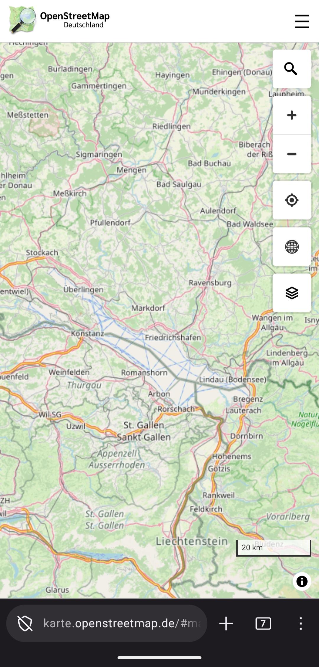
der Bodensee wird im deutschen #OSM Stil weiss angezeigt, im "standard" Stil ist er blau.
-
der Bodensee wird im deutschen #OSM Stil weiss angezeigt, im "standard" Stil ist er blau. Ich frage mich ob das so gewollt ist #openstreetmap @giggls
@jakobmiksch So ausgetrocknet ist es dann doch noch nicht. War halt das Polygon vermutlich zwischenzeitlich kaputt. Schon ein re-rendering für eine einzelne Kachel angeworfen?
-
der Bodensee wird im deutschen #OSM Stil weiss angezeigt, im "standard" Stil ist er blau. Ich frage mich ob das so gewollt ist #openstreetmap @giggls
Es gab einen Fehler in den Daten, der inzwischen behoben wurde. Veraltete Kartenkacheln zeigen den See deshalb nicht korrekt an.
-
der Bodensee wird im deutschen #OSM Stil weiss angezeigt, im "standard" Stil ist er blau. Ich frage mich ob das so gewollt ist #openstreetmap @giggls
@jakobmiksch @giggls It looks blue here, using deutche stil (on pc). the only thing that appears to have changed compared to the default is the major roads (colors and road signs)
-
@jakobmiksch @giggls It looks blue here, using deutche stil (on pc). the only thing that appears to have changed compared to the default is the major roads (colors and road signs)
@anderslund @giggls opening the OSM german style on the phone still shows it white. But as mentioned above the reason is likely a broken relation of Bodensee
-
@anderslund @giggls opening the OSM german style on the phone still shows it white. But as mentioned above the reason is likely a broken relation of Bodensee
@anderslund @giggls zoom levels 6, 7, 8, 9 show white Bodensee, the other zoom levels show blue
maybe a hint how lakes will look in future when temperatures are rising more and more ... -
@anderslund @giggls zoom levels 6, 7, 8, 9 show white Bodensee, the other zoom levels show blue
maybe a hint how lakes will look in future when temperatures are rising more and more ...@jakobmiksch @giggls Not here, for some reason.
-
@jakobmiksch @giggls Not here, for some reason.
@anderslund @jakobmiksch @giggls why not have both?
-
@anderslund @jakobmiksch @giggls why not have both?
@bdm @giggls @jakobmiksch
Are any of you involved in openstreetmap.de? I have a #mapLibre tip - to set map keyboard focus, 'map.getCanvas().focus()' - for example in document.load event. -
@bdm @giggls @jakobmiksch
Are any of you involved in openstreetmap.de? I have a #mapLibre tip - to set map keyboard focus, 'map.getCanvas().focus()' - for example in document.load event.@anderslund @bdm @giggls I am actually developing this webmap
 Thanka for the tip
here is the repo btw https://github.com/fossgis/karte.openstreetmap.de -
@anderslund @bdm @giggls I am actually developing this webmap
Thanka for the tip
here is the repo btw https://github.com/fossgis/karte.openstreetmap.de@jakobmiksch @bdm @giggls Thank you very much. I mainly play with my style, derived from osm-bright, I do have a html page to display it of cause, so looking at your code is inspiring
-
@jakobmiksch @bdm @giggls Thank you very much. I mainly play with my style, derived from osm-bright, I do have a html page to display it of cause, so looking at your code is inspiring
@anderslund @bdm @giggls the idea of the webmap is to keep the code boring without unneeded dependencies
-
@anderslund @bdm @giggls the idea of the webmap is to keep the code boring without unneeded dependencies
@jakobmiksch @bdm @giggls
I really like it, simple as it is.That said, we still have to see a really nice osm-based map application, that can compete with google maps for non-geek users. The best bids I know of is osmapp.org and cartes.app.
They provide some details from the osm database, like opening hours, and images from wikimedia for example. But yes, those gets complex