My openseamap rendering, here with maptiler basic style as background.
-
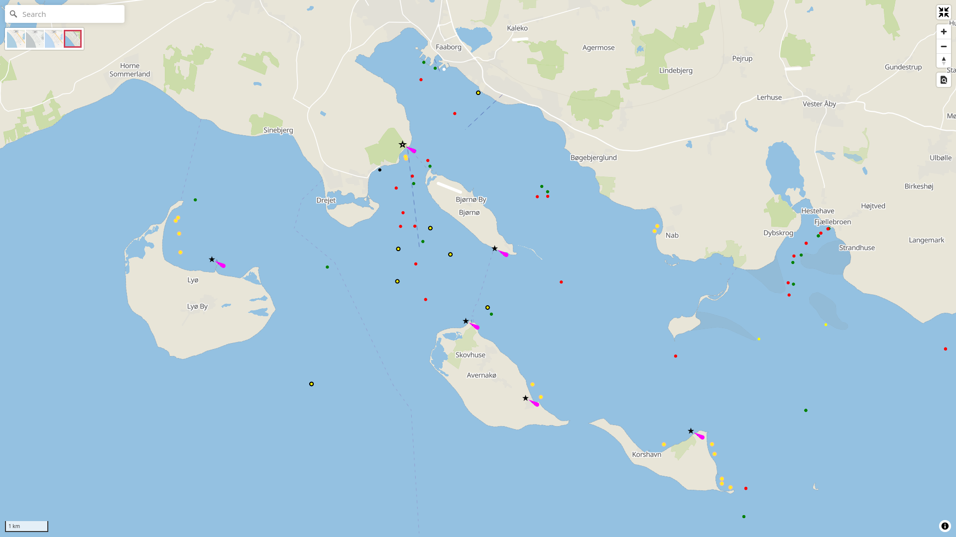
My openseamap rendering, here with maptiler basic openstreetmap style as background. I now have lighthouses (very basic), underwater cables (very light dash lines) and navigation lines (darker dashed lines). The latter have an orientation property that I try to display as a label, but I am not a great friend of the symbol layer

Yellow dots with orange perimeter are mooring buoys.
A sailor should be able to interpret this, just forgive me for not showing the rank of lateral boys, or the orientation of cardinals, I may get to that sometime ...
@anderslund Just out of interest, have you looked into the S-100 portrayal catalogue for the styles that are used there?
Because then the visualisation would be exactly the same as on official navigation equipment (ECDIS etc). Just a thought as there a lot of the symbology would already exist (svg:s etc) but then also colors etc that suit exisiting charts.
-
@anderslund Just out of interest, have you looked into the S-100 portrayal catalogue for the styles that are used there?
Because then the visualisation would be exactly the same as on official navigation equipment (ECDIS etc). Just a thought as there a lot of the symbology would already exist (svg:s etc) but then also colors etc that suit exisiting charts.
@ramin Hi Ramin,
There is lots of icons and other things in the openseamark system on openstreetmap, following the specs. But I am not relally trying to make a seamap for navigation, but maybe for displaying tracks of just overviewing. I started out trying to see if I could render some of the openseamap data, pulled from overpass-turbo in a vector map, which I obviously can.
I actually like the map, using vector graphics I can display the laterals as dots from a lower zoom than usual, I scale them from 1.5px radius to 5. Reaching higher zoom levels, I could display icons, of course. But for now, I am just experimenting, learning to use the maplibre styles and exploring openseamap data a bit closer than before.
-
@anderslund Just out of interest, have you looked into the S-100 portrayal catalogue for the styles that are used there?
Because then the visualisation would be exactly the same as on official navigation equipment (ECDIS etc). Just a thought as there a lot of the symbology would already exist (svg:s etc) but then also colors etc that suit exisiting charts.
@ramin Here is a screenshot at a lower zoom level, just where the laterals (and minor lights) kicks in. As you see, the laterals are just tiny dots, and they nicely tells you where you can go, doesn't they?
")
-
@ramin Here is a screenshot at a lower zoom level, just where the laterals (and minor lights) kicks in. As you see, the laterals are just tiny dots, and they nicely tells you where you can go, doesn't they?
@anderslund Yes they do. But it's interesting to look at this project and at the same time follow the discussions of device manufacturers and how they see things.
-
@anderslund Yes they do. But it's interesting to look at this project and at the same time follow the discussions of device manufacturers and how they see things.
@ramin At some point, I would like to try and convert S57 maps to a format usable in maplibre, and creating a vector style that can display them. It is possible to do the conversoin with GDal tools, or should be at least - I didn't try yet
-
@ramin At some point, I would like to try and convert S57 maps to a format usable in maplibre, and creating a vector style that can display them. It is possible to do the conversoin with GDal tools, or should be at least - I didn't try yet
@anderslund Would using S-101 maybe help with this as it has the styles available as well (and is the next-gen)? I have to admit I haven't looked into actual S-57 or S-101, but have looked into S-124 (navigational warnings) and S-421 (route exchange) quite a bit and have written a plugin for QGis to display S-421 (version 2 that is to be released) routes according to the portrayal catalog (without taking into account turn radius' etc).
-
@anderslund Would using S-101 maybe help with this as it has the styles available as well (and is the next-gen)? I have to admit I haven't looked into actual S-57 or S-101, but have looked into S-124 (navigational warnings) and S-421 (route exchange) quite a bit and have written a plugin for QGis to display S-421 (version 2 that is to be released) routes according to the portrayal catalog (without taking into account turn radius' etc).
@ramin Sounds very interresting and inspiring. I didn't even know about those things (S-124, S421), so now I have something to explore a bit
They sound like something for proffesionals - I just sail in my 25' sailboat ")
-
My openseamap rendering, here with maptiler basic openstreetmap style as background. I now have lighthouses (very basic), underwater cables (very light dash lines) and navigation lines (darker dashed lines). The latter have an orientation property that I try to display as a label, but I am not a great friend of the symbol layer
Yellow dots with orange perimeter are mooring buoys.
A sailor should be able to interpret this, just forgive me for not showing the rank of lateral boys, or the orientation of cardinals, I may get to that sometime ...
Just used Open Sea iPhone app for a week while boating on the Havel.
So much stuff which is not in there, even several locks, most yellow sea marks are missing, several shallow waters not marked...
I have no clue how to add that ... I did edit open street map back in the day. -
Just used Open Sea iPhone app for a week while boating on the Havel.
So much stuff which is not in there, even several locks, most yellow sea marks are missing, several shallow waters not marked...
I have no clue how to add that ... I did edit open street map back in the day.@Ann_Effes Hello
That is why I say OpenSeaMap is not suited for navigation, data may be missing and/or inaccurate. In some areas more than other. -
My openseamap rendering, here with maptiler basic openstreetmap style as background. I now have lighthouses (very basic), underwater cables (very light dash lines) and navigation lines (darker dashed lines). The latter have an orientation property that I try to display as a label, but I am not a great friend of the symbol layer
Yellow dots with orange perimeter are mooring buoys.
A sailor should be able to interpret this, just forgive me for not showing the rank of lateral boys, or the orientation of cardinals, I may get to that sometime ...
I'm making peace with the maplibre style's symbol layer, so now I can display navigation line orientation as a label, and rocks are represented as a '+' label. My issue was that when styling geoJSON, it is nessecary to specify the 'text-font' property.
Next I will try to learn to color symbols dynamically, so that I can display light colors as specified in the data using a single png or svg image for single colored lights - lights with sectors will also be fun, later ...