Implemented support for "ford" (a section of a road that is covered by water) in my vector #openStreetMap style, so far for tracks.
-
Implemented support for "ford" (a section of a road that is covered by water) in my vector #openStreetMap style, so far for tracks. By hand, btw, slowly... Quite simple - just lower the opacity of the way.
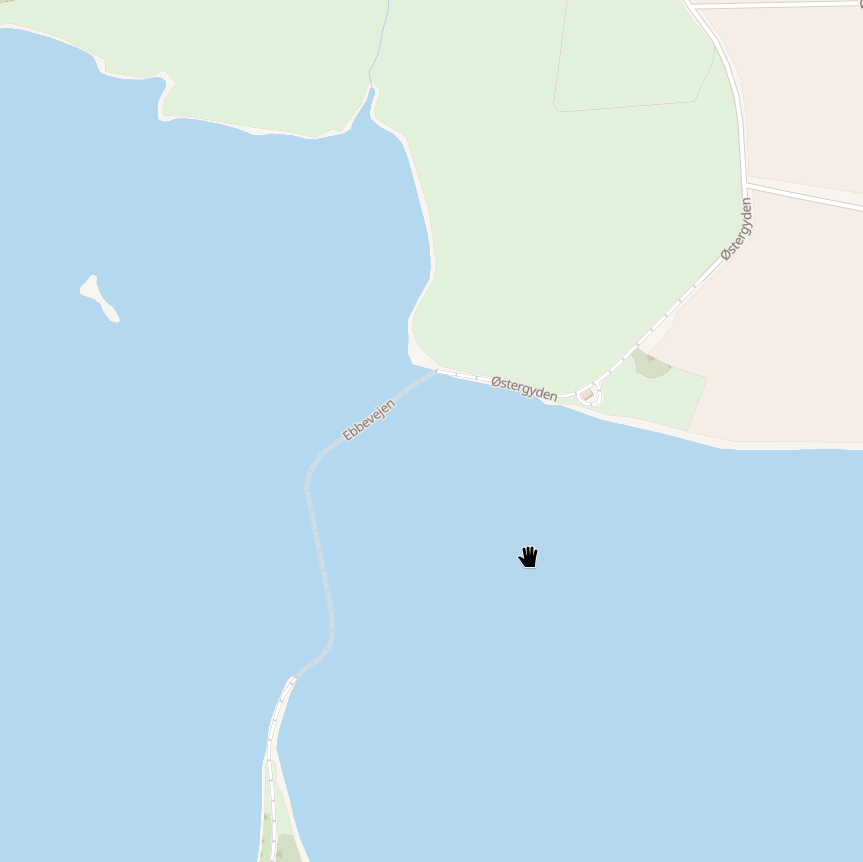
The image shows the way to Svelmø, a small island in southern denmark, where to such a track - "Ebbevejen" - leads.This is not implemented in the OMT vector style

Code: `"line-opacity": ["case", ["==", ["get", "brunnel"], "ford"], 0.3, 1],`
(OSM Carto in addition shows a symbol in the middle of the way, where mappers are supposed to add a point. That is not present in OMT, but you could of course easily put symbols along the line.)
There are 1.560.599 instances of these, 130.771 of which are ways, and thus available in OMT tiles (according to the wiki). In my area primarily tracks, paths and service roads.
-
Implemented support for "ford" (a section of a road that is covered by water) in my vector #openStreetMap style, so far for tracks. By hand, btw, slowly... Quite simple - just lower the opacity of the way.
The image shows the way to Svelmø, a small island in southern denmark, where to such a track - "Ebbevejen" - leads.This is not implemented in the OMT vector style
Code: `"line-opacity": ["case", ["==", ["get", "brunnel"], "ford"], 0.3, 1],`
(OSM Carto in addition shows a symbol in the middle of the way, where mappers are supposed to add a point. That is not present in OMT, but you could of course easily put symbols along the line.)
There are 1.560.599 instances of these, 130.771 of which are ways, and thus available in OMT tiles (according to the wiki). In my area primarily tracks, paths and service roads.
So, after some more research and experimentation I ended up adding symbols for any transportation LineString with brunnel=ford in the tile data. In addition I added some rules to path and track to make them appear a bit translucent, as those are most likely to actually cross water bodies.
I just used a blue "≈" in the text-field.
I'm pretty happy with the overall result, as far as I have seen it in use ...
-
So, after some more research and experimentation I ended up adding symbols for any transportation LineString with brunnel=ford in the tile data. In addition I added some rules to path and track to make them appear a bit translucent, as those are most likely to actually cross water bodies.
I just used a blue "≈" in the text-field.
I'm pretty happy with the overall result, as far as I have seen it in use ...
@anderslund but those in the second screenshot are fords? They feel more like culverts?
-
@anderslund but those in the second screenshot are fords? They feel more like culverts?
@mdione They have "brunnel=ford" in the properties, which is why the symbols are there. I didn't map the area

Here: https://www.openstreetmap.org/way/112749236 -
@mdione They have "brunnel=ford" in the properties, which is why the symbols are there. I didn't map the area
Here: https://www.openstreetmap.org/way/112749236@anderslund `tunnel=`?
-
@anderslund `tunnel=`?
@mdione In OMT, tunnel, bridge, ford are merged into that property. It's defined here: https://github.com/openmaptiles/openmaptiles/blob/master/layers/transportation/transportation.yaml
-
@mdione In OMT, tunnel, bridge, ford are merged into that property. It's defined here: https://github.com/openmaptiles/openmaptiles/blob/master/layers/transportation/transportation.yaml
@anderslund yeah, no, those roads are not properly tagged, a whole road cannot be a ford; a ford is at most the section that crosses a stream or small river, but it's usually a node.
Also, I think those cannot be residential roads if they're withing allotments; maybe tracks or unclassified?
-
@anderslund yeah, no, those roads are not properly tagged, a whole road cannot be a ford; a ford is at most the section that crosses a stream or small river, but it's usually a node.
Also, I think those cannot be residential roads if they're withing allotments; maybe tracks or unclassified?
@mdione I agree, I will make a comment to the relevant changeset, or make a map note, since I have no local knowledge and it is relatively fra from my area.
I just added support for ford to my map styling, and used overpass turbo to see some examples of how it would work, though. There are tons of weird taggings out there -
@mdione I agree, I will make a comment to the relevant changeset, or make a map note, since I have no local knowledge and it is relatively fra from my area.
I just added support for ford to my map styling, and used overpass turbo to see some examples of how it would work, though. There are tons of weird taggings out there@anderslund yes there are. I wrote this, but it's mostly centered on wrong tag values, not wrong tags:
https://www.grulic.org.ar/~mdione/glob/posts/correcting-openstreetmap-wrong-tag-values/
-
@anderslund yes there are. I wrote this, but it's mostly centered on wrong tag values, not wrong tags:
https://www.grulic.org.ar/~mdione/glob/posts/correcting-openstreetmap-wrong-tag-values/
@mdione Yes. Another question is finding a solution - how to tag a road that is sometimes flooded, in this case, since that is the obvious reason for the ford tag being there?